
|
|
| DEUTSCHLAND | GERMANY |
| Bundesland: Hessen | Hesse |
| Regierungsbezirk: Darmstadt | |
| Kreis: Bergstraße |
map →

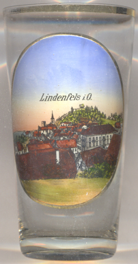 Lindenfels is situated at an elevation of 836 m in the Odenwald region of southern Hesse.
The first written mention of Lindenfels is found in a document of 1123. Some time after that Lindenfels became part of the Margraviate of Baden, and in 1277 it was acquired by Elector Ludwig II of the Palatinate. In 1336 Lindenfels was chartered as a town and it soon became of regional importance. In 1802 Lindenfels became part of the Landgraviate (1806 Grand Duchy) of Hesse-Darmstadt. In the late 19th century Lindenfels evolved into a popular resort place due to its pleasant location and climate. In 1969 it was awarded the predicate 'climatic spa'. In 1971/1972 the neighbouring communities of Eulsbach, Glattbach, Kolmbach, Seidenbuch, Schlierbach, Winkel and Winterkasten were incorporated into the municipality of Lindenfels.
 The
The  castle [background top]
was founded in the 13th/14th century and superseded an older stronghold of the 11th century whic, however,
must have stood at a different location. The castle
did not suffer any major damages throughout the centuries, not even
during the Thirty Years' War (1618–1648). Only when it lost its strategic importance it gradually
fell into dereliction during the 18th century and eventualy was sold in 1774 to be used as a quarry.
The remaining ruins today are apopular tourist attraction.
castle [background top]
was founded in the 13th/14th century and superseded an older stronghold of the 11th century whic, however,
must have stood at a different location. The castle
did not suffer any major damages throughout the centuries, not even
during the Thirty Years' War (1618–1648). Only when it lost its strategic importance it gradually
fell into dereliction during the 18th century and eventualy was sold in 1774 to be used as a quarry.
The remaining ruins today are apopular tourist attraction.
The Protestant parish church [background centre]
was built in 1823–1825.
![[scale]](lineal.jpg)