
|
|
| DEUTSCHLAND | GERMANY |
| Bundesland: Freistaat Thüringen | Thuringia |
| Landkreis: Greiz |
map →

 Greiz is situated at an elevation of 381 m at the river Weiße Elster in the southeast of Thuringia,
directly at the border to Saxony. It is the administrative seat of the district Greiz and has a population
of about 24,600 (2003).
Greiz is situated at an elevation of 381 m at the river Weiße Elster in the southeast of Thuringia,
directly at the border to Saxony. It is the administrative seat of the district Greiz and has a population
of about 24,600 (2003).
Greiz was first mentioned in a document of 1209. Since 1306 it was residence of the Counts of Reuß (Reuss). Greiz was chartered as a town in 1359. In 1449 the town was divided between the lines Reuß-Obergreiz and Reuß-Untergreiz. These lines existed until their reunification in 1768 to Reuß Elder Line, whose members obtained the rank of Princes in 1778. During the 19th century Greiz became an important industrial place. Since 1920 it is part of Thuringia.
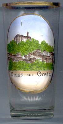
The  upper castle (Oberes Schloss) [left]
is the landmark of Greiz. It is situated on a mount about 50 m above the town.
The castle keep, which is 24 m high, is probably the oldest part of the castle which
was first mentioned in 1209. The oldest parts of the castle were mostly destroyed by a large fire in 1540.
The castle that was rebuilt thereafter is the structure that we see today; only the buildings forming
the lower courtyard weer built later.
upper castle (Oberes Schloss) [left]
is the landmark of Greiz. It is situated on a mount about 50 m above the town.
The castle keep, which is 24 m high, is probably the oldest part of the castle which
was first mentioned in 1209. The oldest parts of the castle were mostly destroyed by a large fire in 1540.
The castle that was rebuilt thereafter is the structure that we see today; only the buildings forming
the lower courtyard weer built later.
A note on the naming convention of the Reuß families: Since about 1200 (and confirmed by the house law
of the Reuß dynasty in 1668) every male born was named Heinrich in honour of Emperor Heinrich VI of Hohenstaufen.
The Elder Line numbered all members sequentially with the last series beginning in 1693.
The members of the Junior Line shared a numbering sequence which began and ended roughly as centuries began and ended.
![[scale]](lineal.jpg)