
|
| DEUTSCHLAND | GERMANY |
| Bundesland: Freistaat Sachsen | Saxony |
| Landkreis: Bautzen |
 Bautzen (until 1868 Budissin) is situated at an elevation of 204 m on a plateau above the river Spree in eastern Saxony.
Bautzen is the administrative seat of the district of the same name and has a population of about 42,100 (2004).
The castle Ortenburg in the old town was first mentioned in 1002 as civitas budusin as the centre of the Upper Lausitz region. Shortly after that it came in possession of the duchy of Poland and remained Polish until 1031. A peace treaty between the Holy Roman Empire and Poland was signed in the castle in 1018. The town which began to develop next to the castle profited from the favourable location at the site where the Via Regia, the important trading route from the Rhineland to Silesia, crossed the river. Until 1635 the Ortenburg was seat of the bailiff of the Upper Lausitz. In 1346 Bautzen was one of six towns that founded the "Oberlausitzer Sechsstädtebund" (Bautzen, Zittau, Görlitz, Kamenz, Löbau and Lauban (Lubań, PL)). Between 1469 and 1490 Bautzen belonged to the Hungarian crown before it passed to the Kingdom of Bohemia. Between 1520 and 1525 the Reformation was introduced into the town, only the collegiate chapter of St. Peter remained Catholic. During the War of Schmalkalden of 1546/47 the Protestant towns of the Upper Lausitz Union were forced to support the Catholic sovereign, Emperor Ferdinand I, King of Bohemia. Because the towns had only provided troops for a limited period, Ferdinand punished the six towns by stripping them of their privileges and their entire estates. In 1623 the Upper Lausitz was pawned to Saxony. During the Thirty Years' War (1618–1648) the town was almost completely destroyed.
During the Napoleonic wars, the French army defeated the coalition forces in a battle that took lpace in 1813 at Wurzen (today part of Weißenberg) near Bautzen. Since Saxony had supported Napoleon, the Congress of Vienna (1815) decided that large parts of the country including about half of the Upper Lausitz with Görlitz and Lauban had to be ceded to Prussia. Bautzen and the three other towns of the former Upper Lausitz Union, however, remained with Saxony. The modern German name of the town, Bautzen, was only made official in 1866; before that, the official name was Budissin.
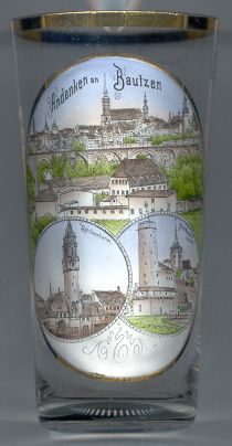
The  church of St. Peter (Dom Sankt Petri) [top picture: centre background]
is the largest church in Germany that is used simultaneously by the Protestant and Catholic communities and the only
such church in eastern Germany. The simultaneous use by both denominations began already during the Reformation.
The first church on this site had already been built around 1000. The choir of the church of the collegiate convent
was consecrated in 1221. Since 1237 St. Peter is the patron saint of the church. The present Late Gothic church dates
from the second half of the 15th century.
In 1921 the Catholic bishopric of Meißen was recreated with Bautzen as its seat. The church thus
became a cathedral church ('Dom'), the only example of a cathedral in Germany used by both confessions. The seat of
the diocese was moved to Dresden in 1980 and now is called diocese of Dresden-Meißen.
The bottom left picture on glass no. 1854 shows the  Reichenturm
The bottom right picture on glass no. 1854 shows the  Alte Wasserkunst
![[scale]](lineal.jpg)