
|
|
| ČESKÁ REPUBLIKA | CZECH REPUBLIC |
| Pardubický kraj | Pardubice region |
| Okres: Chrudim |
map →

 Luže is situated at an elevation of 39 m on the dividing line between the fertile lowlands of the Labe (Elbe) river and
the Bohemian-Moravian highlands, about 22 km east of Chrudim and 11 km southwest of
Vysoké Mýto (Hohenmauth).
Luže is situated at an elevation of 39 m on the dividing line between the fertile lowlands of the Labe (Elbe) river and
the Bohemian-Moravian highlands, about 22 km east of Chrudim and 11 km southwest of
Vysoké Mýto (Hohenmauth).
According to later documents, Luza was founded in 1250 in the vicinity of the older settlement of Kamenicza, which itself has been
mentioned as early as the beginning of the 12th century. The first direct mention is found in a document of 1349 when its church was
assigned to the newly founded bishopric of Litomyšl (Leitomischl). In 2007 the municipality gained the status
of a town.
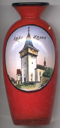
The  church of St. Bartholomew [left, no. 4767] was already mentioned in 1350 as a parish church.
The single-naved Gothic structure was rebuilt significantly in the 19th century, but some parts of the nave retained its Gothic character.
church of St. Bartholomew [left, no. 4767] was already mentioned in 1350 as a parish church.
The single-naved Gothic structure was rebuilt significantly in the 19th century, but some parts of the nave retained its Gothic character.
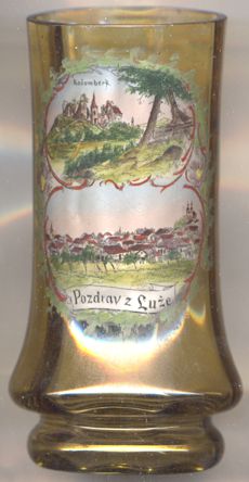
The ruins of Košumberk castle (German: Koschumberg, Rossumberg, older also Roßenburg)
[right, no. 3986: top picture] are located above the Novohradka valley near the village of Košumberk, which belongs
to the town of Luže. The castle was probably founded after 1310. Beginning in 1573, the castle was rebuilt in Renaissance style. Since
the end of the 17th century the castle was owned by the Jesuits who lived in a newly built residence in Chlumek (part of Košumberk/Luže). After the dissolution of the Jesuit order in 1773, the castle fell into
disrepair; the gatehouse has been preserved and, thanks to extensive restoration work, has been converted into a castle museum.
Note: in the labeling on glass no. 3986 the name of the castle is incorrectly spelled Kožumberk instead of
correctly Košumberk.
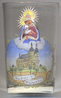
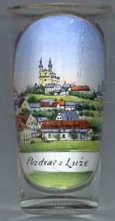
The pilgrimage church of Our Lady [left, no. 4873, and below, nos. 1727 and 4849] was
built in 1690–1696 on the basalt hill Chlumek (379 m) above the town. The early Baroque project was executed by the Italian
architect Giovanni Battista Alliprandi according to plans of Paul Ignaz Bayer on the site of a previous chapel that had been built in
1667–1669. The church has been listed as a cultural monument since 1958 and in 2018 the entire complex with the church, terraced
cloister with eight chapels, staircase, enclosure wall with entrance gates and the adjacent former Jesuit residence was declared a
national cultural monument.

[https://de.wikipedia.org/wiki/Lu%C5%BEe;
https://de.wikipedia.org/wiki/Burg_Ko%C5%A1umberk, https://de.wikipedia.org/wiki/Ko%C5%A1umberk;
https://www.luze.cz/mesto-luze/pamatky-mesta-luze/kostel-sv-bartolomeje/;
https://cs.wikipedia.org/wiki/Kostel_Panny_Marie_Pomocnice_na_Chlumku]
![[scale]](lineal.jpg)