
|
| POLSKA | POLAND |
| województwo: Dolnośląskie | voivodship: Lower Silesia |
| powiat: Świdnica | county: Świdnica |
 Jaworzyna Śląska is situated at an elevation of 212 m northwest of the county seat Świdnica in Lower
Silesia.
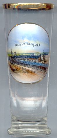
The  railway station [left] was built in 1843 for the railroad from
Wrocław (Breslau) to Świdnica (Schweidnitz) and Świebodzice (Freiburg). At that time
there was no village at this place so that a new place name had to be invented. Because it was believed that near this place
King Friedrich II (the Great) of Prussia had set up his tent during the Seven Year's War (1756–1763), the station
was named Königszelt (German for King's tent). The town that soon began to develop at this place also
took this name. Königszelt became an important railroad junction after the opening in 1853 of the railroad from
Waldenburg (now Wałbrzych) to Liegnitz (now Legnica) and the
construction in 1863 of the railroad from Waldenburg to Schweidnitz (now Świdnica) and Neiße (now
Nysa). When Lower Silesia became part of Poland after World War II in 1945 Königszelt
was at first renamed Jawornik Świdnicki, which was later changed to the present name, Jaworzyna
Śląska.
![[scale]](lineal.jpg)