
|
|
| POLSKA | POLAND |
| województwo: Śląskie | voivodship: Silesia |
| powiat: Cieszyn | county: Cieszyn |
map →

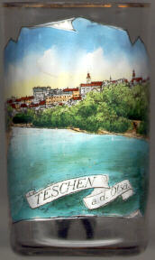
Cieszyn (German: Teschen, Czech: Těšín) is situated at an elevation of 379 m on the right bank of the river Olza (Czech: Olše, German: Olsa), which here formes the border between Poland and the Czech Republic. Across the river lies the Czech town of Český Těšín, once part of the historic town. The municipality of Cieszyn has a population of about 32,900 (2023).
 The area has been populated by West Slavic peoples since at least the 7th century. According to legend, in 810 three sons of a prince,
Bolko, Leszko and Cieszko, met here after a long pilgrimage, found a spring, and decided to found a new settlement. The area became part of
the emerging Polish state in the 10th century. The city's oldest surviving buildings date back to the 11th century. The city itself
was first mentioned in documents in 1155. The town was the capital of the Duchy of Cieszyn, established during the fragmentation of Poland into
smaller duchies, since 1290, which was ruled by Piast dynasty until 1653 and by the Habsburg Dynasty of Austria until 1918. The title of Duke of
Teschen was borne by Leopold Joseph of Lorraine from 1722, then by his son Emperor Franz I (Franz Stephan of Lorraine, husband of Maria
Theresia of Austria), then by their daughter Maria Christine and her husband Duke Albrecht von Saxe-Teschen. It was in Teschen that Maria
Theresia of Austria and Friedrich II of Prussia in May 1779 signed the Teschen Peace Treaty, which put an end to the War of the Bavarian
Succession.
The area has been populated by West Slavic peoples since at least the 7th century. According to legend, in 810 three sons of a prince,
Bolko, Leszko and Cieszko, met here after a long pilgrimage, found a spring, and decided to found a new settlement. The area became part of
the emerging Polish state in the 10th century. The city's oldest surviving buildings date back to the 11th century. The city itself
was first mentioned in documents in 1155. The town was the capital of the Duchy of Cieszyn, established during the fragmentation of Poland into
smaller duchies, since 1290, which was ruled by Piast dynasty until 1653 and by the Habsburg Dynasty of Austria until 1918. The title of Duke of
Teschen was borne by Leopold Joseph of Lorraine from 1722, then by his son Emperor Franz I (Franz Stephan of Lorraine, husband of Maria
Theresia of Austria), then by their daughter Maria Christine and her husband Duke Albrecht von Saxe-Teschen. It was in Teschen that Maria
Theresia of Austria and Friedrich II of Prussia in May 1779 signed the Teschen Peace Treaty, which put an end to the War of the Bavarian
Succession.
After the dissolution of the Austro-Hungarian Monarchy, the historic part of the town on the right bank [see glass] became part of Poland (Cieszyn), whereas the new town and the industrial area on the left bank became of part of the Czechoslovak Republic (Český Těšín). After the Treaty of Munich, Český Těšín was occupied by Poland (together with the Czech towns of Karviná, Orlová, Bohumín and Petrovice). In 1939 Cieszyn was occupied by Germany and became part of Upper Silesia (except Český Těšín, which became part of the Protectorate Bohemia and Moravia). Since 1945, the river Olza (Czech: Olše, German: Olsa) again marks the border between Poland (Cieszyn) and the Czechoslovak (today Czech) Republic (Český Těšín).
The Austrian politician Rudolf Ramek (1881–1941; Chancellor of Austria 1924–1926) was born in Teschen / Cieszyn / Těšín.
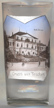
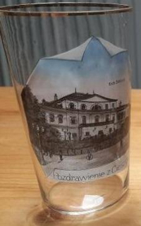
The  Archducal palace [near left, no. 4660] was built in 1838–1840 in Classicist
style by the Viennese architect Joseph Kornhäusel for Archduke Karl, Duke of Teschen, third son of
Emperor Leopold II. The site had been previously occupied by the upper and lower castles that had been destroyed during the
Thirty Years' War (1618–1648). While the upper castle was removed completely to make room for an English park, the ruins of
the lower castle were rebuild into a residential hunting palace. The palace did not perform its original function. It was rarely visited
by the Habsburgs (who most often stayed in Vienna) and on everyday basis was the seat of the Chamber of Cieszyn, the administration
of the lands owned personally by the Habsburgs in this area. In 1918 the Hunting Palace became the seat of the National Council of the
Duchy of Cieszyn, the first Polish authority in the area of Cieszyn Silesia. Since 1974 a part of the Hunting Palace has been the seat
of the Ignacy Paderewski State School of Music. Since 2005 the remaining part of the palace and a newly build conservatory has served as
the seat of Zamek Cieszyn, a cultural institution that is a design centre.
Archducal palace [near left, no. 4660] was built in 1838–1840 in Classicist
style by the Viennese architect Joseph Kornhäusel for Archduke Karl, Duke of Teschen, third son of
Emperor Leopold II. The site had been previously occupied by the upper and lower castles that had been destroyed during the
Thirty Years' War (1618–1648). While the upper castle was removed completely to make room for an English park, the ruins of
the lower castle were rebuild into a residential hunting palace. The palace did not perform its original function. It was rarely visited
by the Habsburgs (who most often stayed in Vienna) and on everyday basis was the seat of the Chamber of Cieszyn, the administration
of the lands owned personally by the Habsburgs in this area. In 1918 the Hunting Palace became the seat of the National Council of the
Duchy of Cieszyn, the first Polish authority in the area of Cieszyn Silesia. Since 1974 a part of the Hunting Palace has been the seat
of the Ignacy Paderewski State School of Music. Since 2005 the remaining part of the palace and a newly build conservatory has served as
the seat of Zamek Cieszyn, a cultural institution that is a design centre.
Note: glass no. 4660 [left] and glass no. 4976 [right] are decorated with the identical picture, but of course are coloured by hand in a slightly different way. While the labeling within the picture identifying the building as the archducal palace in both cases is in German, Erzh[erzogliches] Schloss, the labeling on the bottom as 'souvenir from Cieszyn' is in German (Gruss aus Teschen) in case of glass no. 4660 [left] and in Polish (Pozdrawienie z Cieszynia) in case of glass no. 4976 [right].
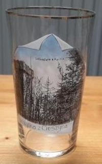
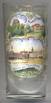
The Piast tower [left, no. 4975] is a defence tower of the former castle of Cieszyn on
Castle Hill, one of the four that once existed there and the only one that survived. It was built in the first part of the 14th century
and was a part of the upper castle. The upper storey was added in tthe 15th century. The tower is almost 30 metres high with
120 stairs leading to the top. The tower has been renovated many times, the last renovation took place in 2015. Throughout the ages the
tower has been recognised as a symbol of Cieszyn, a testimony of its Piast past and Poles keeping guard on the Olza river.
The rotunda of St. Nicholas [background right, behind the trees, barely visible]
was built in the 11th or 12th century as a castle chapel and stronghold church. It was first mentioned in a written docuemtn from 1223.
After the last member of the Piast dynasty died in 1653, the chapel became the property of the Chamber of Cieszyn, established by the Habsburg
dynasty. During the conversion of the lower castle in 1838 to 40, the rotunda underwent major changes.
Glass no.&8239;4975 [left] is labeled on the bottom in Polish Pamiatka z Cieszyna ('souvenir from Cieszyn'), while the view depicted is labeled in German Schlossturm u[nd] Kapelle ('castle tower and chapel').
Glass no. 4871 [near left] shows pictures of the Archducal Palace [top right] and Piast tower
[top left] (see above).
The bottom picture shows a view of the Ringplatz
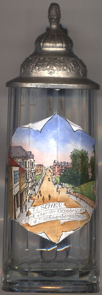
The picture on glass no. 2843 [near left] shows a view across the bridge over the river (about where the trees are
depicted on the right) into the street Sachsenberg
[https://de.wikipedia.org/wiki/Cieszyn;
https://en.wikipedia.org/wiki/Cieszyn, https://pl.wikipedia.org/wiki/Cieszyn;
https://en.wikipedia.org/wiki/Habsburg_Palace,_Cieszyn, https://en.wikipedia.org/wiki/Piast_tower_in_Cieszyn, https://en.wikipedia.org/wiki/Rotunda_of_Saint_Nicolas_in_Cieszyn;
https://en.wikipedia.org/wiki/Archduke_Charles,_Duke_of_Teschen]
![[scale]](lineal.jpg)