
|
|
| DEUTSCHLAND | GERMANY |
| Bundesland: Baden-Württemberg | |
| Regierungsbezirk: Freiburg | |
| Landkreis: Rottweil |
map →

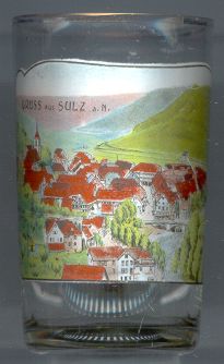 Sulz am Neckar is situated at an elevation of 515 m in the valleys of the rivers Neckar, Glatt and Mühlbach.
The earliest traces of humans settlements date back to Celtic times. The Romans built a fort on a hill above Sulz in AD 74 but left it soon after that. The earlist mention of the "villa publica Sulza" dates from 790. The name is derived from the saline springs which determined the history of Sulz for many centuries. Sulz obtained the official status of a town in 1284. From 1473 onward it was part of Württemberg and for more than there centuries remained the country's only saltern. In 1483 the town became the administrative centre of the Schwarzwald (Black Forest) region. The Thirty Years' War (1618–1648) caused a serious decline for Sulz. After a large fire in 1794, which destroyed most of the old town, Sulz was rebuilt according to new plans. However, it did not regain its former importance, especially when much more profitable salt works were established in 1803 at the Kocher river. Today Sulz and its town district Glatt are officially recognized recreation resorts.
Gustav BAUERNFEIND (1848–1904), Germany's most prominent Orientalism painter, was born in Sulz am Neckar.
![[scale]](lineal.jpg)