
|
| ČESKÁ REPUBLIKA | CZECH REPUBLIC |
| Vysočina | Highlands (Jihlava) region |
| Okres: Žďár nad Sázavou |
 Vír (German: Wühr) is situated at an elevation of 384 m on the river Svratka (Schwarza, Schwarzawa).
The place was first mentioned in the first half of the 12th century.
During the 1880s, Vír became a centre of tourism in the upland region between Moravia and Bohemia.
The waters of the river Svratka were tamed by a dam built in the 1950s.
Glass no. 1370 [left] is labeled in Czech: Vír / Českomor[avská] vysočina ('Vír / Bohemian-Moravian Highlands').

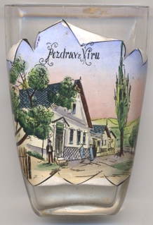
Glass no. 4432 [near left] is labaled Pozdrav z Víru ('Greetings from Vír').
Based on the views printed on old picture postcards from Vír, the group of houses depicted on this glass should be
 Šťastny's
![[scale]](lineal.jpg)