
|
|
| ČESKÁ REPUBLIKA | CZECH REPUBLIC |
| Ústecký kraj | Ústí nad Labem region |
| Okres: Děčín |
map →

 Jiřetín pod Jedlovou is situated at an elevation of 458 m in the northern foothills of the
Lužické hory (Lusatian Mountains, Lausitzer Gebirge) in North Bohemia.
Jiřetín pod Jedlovou is situated at an elevation of 458 m in the northern foothills of the
Lužické hory (Lusatian Mountains, Lausitzer Gebirge) in North Bohemia.
Sankt Georgenthal, named after the patron saint of the founder, was founded in 1554 on a regular ground plan of Saxon mining towns for the miners who were called into the area in 1548. Mining for gold, silver, copper, lead and other metals in this area had already been documented in 1474 and 1484. In 1587, the village obtained the status of a royal mining town. Minig for copper, silver and tin flourished until the times of the Tirty Years' War (1618–1648) but declined thereafter and was finally ended in 1888. After 1945, the German population was expelled and the town's population thus was reduced from about 2,000 before the war to less than 1,000 and the statuts of a town was removed. Sankt Georgenthal was initially translated to Svatý Jiřetín. When the villages of Svatý Jiřetín, Rozhled (Tollenstein; see below), Lesné (Innozenzidorf) and Jedlová (Tannendorf; see below) were merged into a single municipality in 1949, the new municipality was renamed Jiřetín pod Jedlovou.
The mountain
Jedlová (German: Tannendorf) is situated at an elevation of 535–600 m just north of the
Jedlová (Tannenberg) mountain. Tannendorf was first mentioned in a document of 1787. Together with
Tollenstein (Czech: Rozhled) it formed a municipality since 1869. After the expulsion of the German population following
World War II, most of the then abandoned houses were demolished. Since 1949, Jedlová is part of the
municipality Jiřetín pod Jedlovou.
The
Rozhled (German: Tollenstein) was first mentioned as Tollendorf in 1471. Following the abolition of manorial rule,
Tollenstein, together with the nearby village of Innozenzendorf (now Lesné), became an independent municipality within the judicial
district of Warnsdorf (Varnsdorf) in 1849; from 1869, Tannendorf (now Jedlová) was also incorporated into
this municipality. Following the expulsion of the German inhabitants after the World War II, the depopulated village was incorporated
into Jiřetín pod Jedlovou in 1949. Many of the empty houses were demolished over the following decades. Tollenstein was given
the new Czech name Tolštýn, which was later changed again to Rozhled.
[https://de.wikipedia.org/wiki/Jiřetín_pod_Jedlovou;
https://de.wikipedia.org/wiki/Křížová_hora_(Lausitzer_Gebirge),
https://cs.wikipedia.org/wiki/Křížová_hora_(Lužické_hory);
https://de.wikipedia.org/wiki/Jedlová_(Jiřetín_pod_Jedlovou),
https://de.wikipedia.org/wiki/Jedlová_(Berg);
https://de.wikipedia.org/wiki/Rozhled;
https://en.wikipedia.org/wiki/Tol%C5%A1tejn_Castle]
 Křížová hora [left] (Kreuzberg; 563 m)
near Jiřetín pod Jedlovou has been a popular pilgrimage site since the 18th century. The pilgrimages go back
to tales of a miracle-working crucifix, which, according to the legends, had been erected here in 1669. In 1759–1764,
eleven stations of the cross, a wooden chapel with the 12th and 13th station, and a Rococo chapel with the Holy Sepulcre
were built. The wooden chapel was destroyed by a storm in 1779, and was replaced by a new brick chapel in 1783–1796.
The massive tower was added in 1881–1888. The complex was listed as a cultural monument in 1969.
Křížová hora [left] (Kreuzberg; 563 m)
near Jiřetín pod Jedlovou has been a popular pilgrimage site since the 18th century. The pilgrimages go back
to tales of a miracle-working crucifix, which, according to the legends, had been erected here in 1669. In 1759–1764,
eleven stations of the cross, a wooden chapel with the 12th and 13th station, and a Rococo chapel with the Holy Sepulcre
were built. The wooden chapel was destroyed by a storm in 1779, and was replaced by a new brick chapel in 1783–1796.
The massive tower was added in 1881–1888. The complex was listed as a cultural monument in 1969.
Jedlová

The country inn Pfeiferbaude (Pfeiferova bouda) [left, no. 3343] is one of the
old buildings in Jedlová that still exist.
Jedlová (German: Tannenberg) [left: background] is the third highest
elevation (774 m) in the Lužické hory (Lusatian Mountains, Lausitzer Gebirge) in North Bohemia.
Rozhled
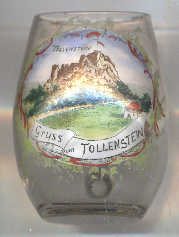
Tolštejn castle [left, no. 5031]
is situated on the Tolštejn mountain, about 4 km south of 2 km south of Jiřetín pod Jedlovou and about
1 km southeast of Rozhled. The existance of a castle was first mentioned in 1337. It was built for the protection of the road from
Bohemia to Lusatia. In 1642, during the Thirty Years' War (1618–1648), it was burned down by the Swedish Army and was never restored.
Today the ruins of the castle are one of the most visited places in the region. A restaurant was built in 1865, which is still in operation.
![[scale]](lineal.jpg) contact: webmaster
contact: webmaster