
|
|
| ČESKÁ REPUBLIKA | CZECH REPUBLIC |
| Vysočina | Highlands (Jihlava) region |
| Okres: Žďár nad Sázavou |
map →

 Žďár nad Sázavou is situated at an elevation of 580 m on the river Sázava.
The history of the place goes back to a hermitage that was founded in 1240 by monks from the monastery at Osek (Osseg).
In 1251, the hermitage became a Cistercian monastery. During the Hussite Wars, the village and the monastery were destroyed
in 1422. After the wars it was rebuilt and became a town in 1607. The monastery was renovated in the Baroque period, but
was eventually was closed in 1784. Since then, the former monastery was used as a residential castle. Today, the castle
belongs to the National Museum at Prague.
Žďár nad Sázavou is situated at an elevation of 580 m on the river Sázava.
The history of the place goes back to a hermitage that was founded in 1240 by monks from the monastery at Osek (Osseg).
In 1251, the hermitage became a Cistercian monastery. During the Hussite Wars, the village and the monastery were destroyed
in 1422. After the wars it was rebuilt and became a town in 1607. The monastery was renovated in the Baroque period, but
was eventually was closed in 1784. Since then, the former monastery was used as a residential castle. Today, the castle
belongs to the National Museum at Prague.
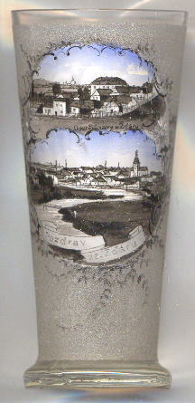
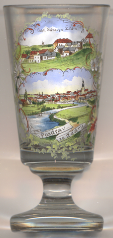
The view depicted in the top pictures on glasses no. 0000 [left] and no. 3700 [right] is labeled Údolí Sázavy u Žďáru, 'Sázava valley near Žďár'.
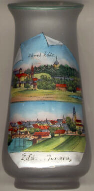
The two pictures on glass no. 116 [left] show the two parts of Žďár,
 Zámek Žďár (Saar-Schloss) [top] and
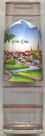
Město Žďár (Saar-Stadt) [bottom].
Zámek Žďár (Saar-Schloss) [top] and
Město Žďár (Saar-Stadt) [bottom].
The pilgrimage chapel [top picture: background] on the hill Zelená Hora
(Grüner Berg) was built in 1719–1722 by the architect Giovanni (Jan Blažej) Santini-Aichel. The chapel is
dedicated to the most popular saint of Bohemia, St. John of Nepomuk.
![[scale]](lineal.jpg)