
|
| ČESKÁ REPUBLIKA | CZECH REPUBLIC |
| Středočeský kraj | Central Bohemia region |
| Okres: Kutná Hora |
 Žleby is situated at an elevation of 243 m at the confluence of the Hostačovka into the Doubrava river
in the east of central Bohemia, about 17 km southeast of the district town Kutná Hora and
about 78 km southeast of Prague. The municipality has a population of about 1,400 (2023).
The oldest written document mentioning Žleby dates from 1278. In later times, the town was known as Broden (1290), Slewen (1322), Zlebin (1327), Sleb and Slebin. In 1356 it obtained the status and privileges of a town. After the end of patrimonialism, Žleby (in German: Schleb) became a parket town in the judicial district Tschaslau (Časlav), from 1868 in the district Tschaslau. In 1960 the district Časlav was dissolved and Žleby became part of the district Kutná Hora.
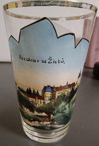
 Žleby castle [left, no. 0000: background right] was originally built
in 1289 by the lords of Lichtenburg, but was destroyed during the Hussite wars in the middle of the 15th century. The estates
were bought in 1730 by the counts of Schönfeld and the castle was subsequently remodeled in High Baroque style. The castle was
later remodeled again by the princes of Auersperg in Historistic style but without respecting the pre-existing architectural style.
At oresent, the castle is state-owned.
[https://de.wikipedia.org/wiki/%C5%BDleby;
https://de.wikipedia.org/wiki/Schloss_%C5%BDleby]
![[scale]](lineal.jpg)