
|
|
| DEUTSCHLAND | GERMANY |
| Bundesland: Mecklenburg-Vorpommern | Mecklenburg-West Pomerania |
| Landkreis: Nordwestmecklenburg |
map →

 Schönberg is situated at an elevation of 7 m on the river Maurine about 36 km east-southeast of the district
town Wismar and about 40 km northwest of Schwerin, the capital of Germany's
state of Mecklenburg-Vorpommern. The municipality has a population of about 4,300 (2025).
Schönberg is situated at an elevation of 7 m on the river Maurine about 36 km east-southeast of the district
town Wismar and about 40 km northwest of Schwerin, the capital of Germany's
state of Mecklenburg-Vorpommern. The municipality has a population of about 4,300 (2025).
Sconenberge was first mentioned in a written document in 1219. At the beginning of the 14th century it became a seat of the bishops of Ratzeburg. The Bishopric of Ratzeburg passed to Mecklenburg as the Principality of Ratzeburg following the Thirty Years’ War (1618–1648) and, from 1701, formed part of the Duchy of Mecklenburg-Strelitz. In 1822, Schönberg was granted town status. In 1934, the districts (Ämter) of Grevesmühlen and Schönberg were merged to form the district of Schönberg as part of the reunification of the two Mecklenburgs (Schwerin and Strelitz). The district administration, which was initially based in Schönberg, was relocated in 1949 to Grevesmühlen. Since 1994, the town has been part of the district of Nordwestmecklenburg.
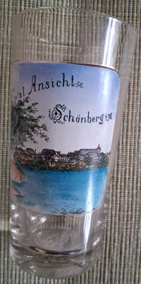
The  church of Sankt Laurentius [left, no. 0000: background centre, barely visible]
goes back to a church that was founded in 1235. That church was enlarged after 1324. The massive west tower was added in the early
16th century. The church was severely damaged by a fire in 1601 and was restored subsequently. After a lightning had struck the tower in
1829, it was restored to its present form in 1831. Restaurations of the church were carried out in 1846–1848 and in 1987–1991.
church of Sankt Laurentius [left, no. 0000: background centre, barely visible]
goes back to a church that was founded in 1235. That church was enlarged after 1324. The massive west tower was added in the early
16th century. The church was severely damaged by a fire in 1601 and was restored subsequently. After a lightning had struck the tower in
1829, it was restored to its present form in 1831. Restaurations of the church were carried out in 1846–1848 and in 1987–1991.
[https://de.wikipedia.org/wiki/Sch%C3%B6nberg_(Mecklenburg)]
![[scale]](lineal.jpg)