
|
| ČESKÁ REPUBLIKA | CZECH REPUBLIC |
| Vysočina | Highlands (Jihlava) region |
| Okres: Třebíč |
 Náměšť nad Oslavou is situated at an elevation of 365 m on the river Oslava in the southeast of the
Highlands region of Czechia, about 20 km east of the district town Třebíč and about 47 km
southeast of the regional capital, Jihlava. The municipality has a population of about 4,800 (2023).
The settlement likely was founded around 1220. The first written mention of Náměšť dates from 1234. In 1886 the town was connected to the railway network. In 1923 it obtained the status of a town.
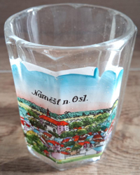
 Náměšť nad Oslavou castle [background centre] was built in 1565–1578
by rebuilding a prrevious, Gothic stronghold. The castle has been a museum since 1949. It has been undergoing extensive renovation since 2016 under
the aegis of the National Institute of Cultural Heritage and the Ministry of Culture of the Czech Republic. The castle is famous for its extensive
collection of tapestries, most of which date from the 17th and 18th centuries, but some exhibits are even older.
[https://de.wikipedia.org/wiki/N%C3%A1m%C4%9B%C5%A1%C5%A5_nad_Oslavou, https://en.wikipedia.org/wiki/N%C3%A1m%C4%9B%C5%A1%C5%A5_nad_Oslavou;
https://de.wikipedia.org/wiki/Schloss_N%C3%A1m%C4%9B%C5%A1%C5%A5_nad_Oslavou]
![[scale]](lineal.jpg)