
|
| ČESKÁ REPUBLIKA | CZECH REPUBLIC |
| Pardubický kraj | Pardubice region |
| Okres: Svitavy |
 Moravská Třebová (in German: Mährisch-Trübau) is situated at an elevation of 360 m on the river
Třebůvka, a tributary of the river Morava, in the Hřebečsko region in the north of the historical region of Moravia,
about 14 km east of the district town Svitavy, and about 70 km southeast of Pardubice,
the administrative centre of the modern administrative region. The historic capital of Moravia, Brno, lies 64 km to
the south. The municipality of Moravská Třebová has a population of about 9,700 (2023).
Moravská Třebová was founded around 1257 by the lords of Rýzmburk as a typical colonization town. Since its foundation
it was part of the Kingdom of Bohemia. In 1469 it passed under Hungarian rule, and in 1490 it returned to Bohemia. The greatest boom occurred between
1486 and 1622, when the town was the centre of humanistic scholarship and earned the nickname "Moravian Athens". From 1804, along with Bohemia, it was
ruled by the Austrian Empire, and after the compromise of 1867 it was part of the Austrian ppart of Austria-Hungary, within which it was the seat of
the district with the same name. Moravská Třebová was located in the largest German linguistic enclave within Bohemia and Moravia.
Until the expulsion of the Germans in 1945 according to the Beneš decrees and Potsdam Agreement, it was mainly
inhabited by German-speaking population. During the German occupation in World War II, the occupiers operated the
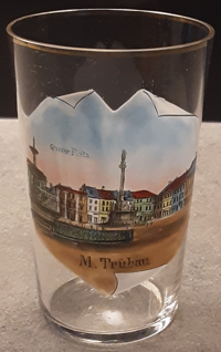
The centre of the town is marked by the regular rectangular
 T. G. Masaryk
 plague column
Other glasses in this collections are from
Česká Třebová (previously in German: Böhmisch-Trübau).
[https://de.wikipedia.org/wiki/Moravsk%C3%A1_T%C5%99ebov%C3%A1, https://en.wikipedia.org/wiki/Moravsk%C3%A1_T%C5%99ebov%C3%A1]
![[scale]](lineal.jpg)